UN ADOPTS RESOLUTION SUPPORTING A MORE ACCURATE WORLD MAP
NEW YORK: The United Nations General Assembly has voted overwhelmingly in favour of a resolution calling for a more accurate representation of the world’s continents, in a move that could change how the world is portrayed on maps.
The resolution, titled “Correct the Map: Rebalancing global cartographic representation and promoting equitable representation of the world’s regions, particularly Africa,” was adopted on Friday, 4 September 2026.
The vote saw 164 countries voting in favour, while the United States was the only country to vote against.
Six countries — Serbia, Estonia, Georgia, Lithuania, Moldova and Ukraine — abstained.
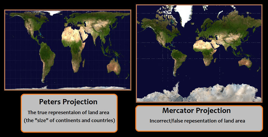
The initiative, spearheaded by Togo and backed by African states, promotes greater use of the Equal Earth projection, which provides a more proportionally accurate representation of the size of the world’s land masses.
The move challenges the long-standing dominance of the Mercator projection, a map design developed in the 16th century primarily for navigation.
While useful for maritime navigation, the Mercator projection significantly exaggerates the apparent size of territories closer to the North and South Poles.
One of the most commonly cited examples is Greenland and Africa.
On many Mercator maps, Greenland appears comparable in size to Africa. In reality, Africa is approximately 14 times larger than Greenland.
The Equal Earth projection seeks to correct this distortion by maintaining the relative areas of continents more accurately.
This means Africa appears substantially larger in relation to Europe, North America and Greenland than it does on a traditional Mercator map.
The resolution has particular significance for African countries, which have argued that the way the world is visually represented can influence perceptions of the continent’s geographical importance and scale.
However, the UN resolution does not legally ban the Mercator projection.
Instead, it encourages governments, educational institutions, media organisations and technology companies to consider adopting more accurate projections for general world maps.
Mercator remains useful for certain navigation purposes.
The adoption of the resolution marks a significant moment in the global debate over cartographic representation and comes amid broader efforts to challenge historical geographical representations that have shaped how different regions of the world are perceived.
With 164 votes in favour, the UN General Assembly has sent a strong political message in support of maps that more accurately reflect the true relative size of the world’s continents.