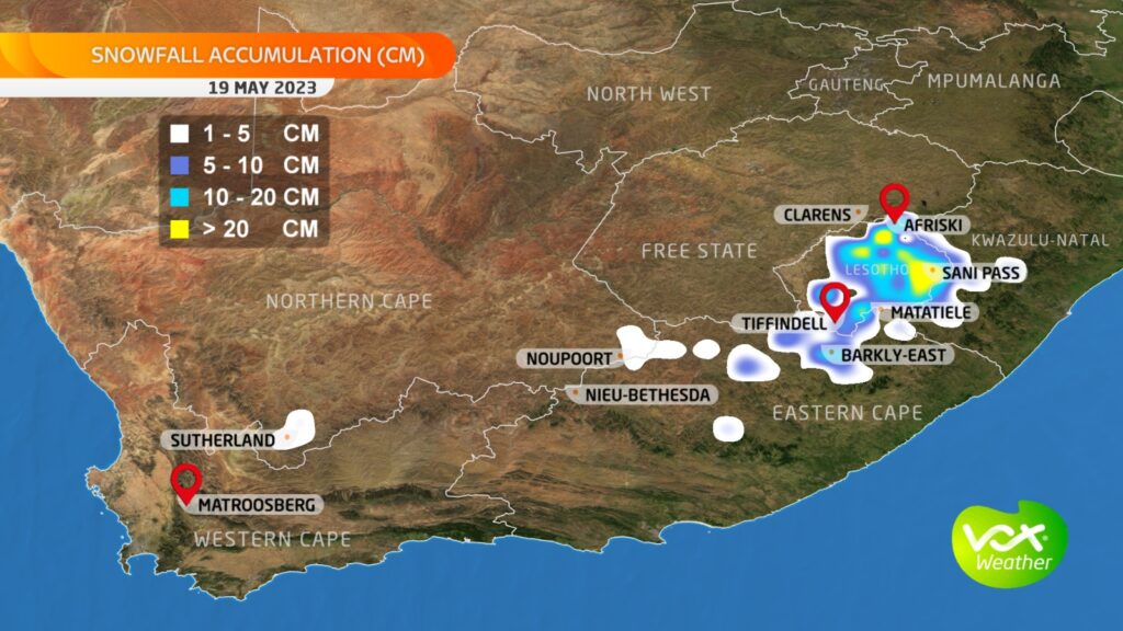
Brace yourself! Very COLD temperatures and more SNOW are expected today in these parts of South Africa.
VERY COLD WEATHER AND SNOW ARE EXPECTED FROM TODAY
According to Vox Weather, forecaster Annette Botha the freezing levels are expected to drop significantly from Thursday into Friday.
This is as two fronts and an upper-level trough are expected to bring RAIN, SNOW, and a SIGNIFICANT DROP IN TEMPERATURE across the Cape Provinces.
‘VERY LIGHT FLURRIES ARE LIKELY ON THURSDAY WHILE MORE SIGNIFICANT SNOW IS EXPECTED ON FRIDAY’
“Very light flurries are likely on Thursday in Sutherland and spreading to the north-eastern mountains of the Eastern Cape and southern Drakensberg into Friday.”
Annette Botha
She furthermore said significant snow of more than 10cm in places is expected to fall on Friday over the mountains of Lesotho and Sani Pass.
SIGNIFICANT SNOW OF MORE THAN 10CM IS EXPECTED IN PLACE
“We are keeping an eye on the possibility of ground snow falling near Barkly East, but as we saw last week, the forecast can quickly change as the weather systems move across the country, and the snow could also quickly melt as it falls with rain.”
Annette said the Vox Weather team would be monitoring the situation closely and would be able to give another weather update tomorrow.
WHY ARE THE FREEZING TEMPERATURES EXPECTED?
The Weather Hooligan Juandre Vorster explained that polar air is currently at 700hpa 3000m AI minus 2.2 degrees above sea level tipping in the Cape Peninsula.
“Keeping that air mass at that level to the interior of South Africa will drop altitude and warm up as it makes landfall over the country. Remember, as an upper-level polar air mass drops altitude, it warms up and starts stabilizing through the week with plummeting temperatures.”
Juandre Vorster
He said temperatures could plummet down to single digits over South Africa.
“Sutherland on Saturday is expected at + – 2 degrees and interior and northern parts of SA to a low of 2 degrees. Temperatures from 2 degrees to 4 are expected in Johannesburg on Saturday.”
Juandre is a weather lover and meteorological hobbyist.
PLEASE SEND US YOUR SNOW PHOTOS AND VIDEOS:
Please WhatsApp your photos and videos to 060 011 0211. Please remember to include your name, surname, and as many details and information as you have. You are, of course, welcome to send anonymous tips and information.
Meanwhile, the SA Weather Services (SAWS) has issued a level 2 warning for disruptive rain in Gqeberha for tomorrow.
A LEVEL 2 WARNING FOR DISRUPTIVE RAIN IS IN PLACE ON THURSDAY
The warning is in place from 12:00 until midnight on Thursday.
It warned that localised flooding of susceptible settlements (formal/informal), roads, low-lying areas and bridges are possible.
As well as localised damage to mud-based and makeshift houses or structures.
See more weather on the live blog here: Weather live updates
“Difficult and dangerous driving conditions due to slippery roads and reduced visibility. Traffic disruptions due to localised flooding. Localised disruption to livelihoods.”
SAWS
THE PUBLIC IS ADVISED TO TAKE NECESSARY PRECAUTIONS TO SECURE THEIR PROPERTIES
The SAWS advised the public to take necessary precautions to secure their properties.
“They are also advised to be aware of flooded areas when crossing streams/rivers or driving, and try to avoid them if possible, especially areas prone to flooding.”
ALSO READ: Stage 11 load shedding could be implemented this winter

