
Cold Fronts and Snowfall Set to Disrupt Parts of South Africa This Week
A wave of intense winter weather is sweeping across South Africa, with strong winds, rough seas, and snowfall expected in several provinces. Multiple weather warnings have been issued as cold fronts begin to make landfall, signaling a week of potentially hazardous conditions.
The first of these fronts arrived on Monday morning along the southwestern coast, bringing powerful winds and sea swells reaching up to 5.5 meters. A second front is expected to follow by evening, worsening conditions along the Western Cape shoreline.
Authorities have warned of possible disruptions to beachfront activities. Large waves could pose a danger to those near the water, especially anglers and coastal users on low-lying rocks.
By Monday night, coastlines stretching from Saldanha Bay to Cape Agulhas will likely face dangerous swell activity. These conditions are forecast to spread eastward by Tuesday, affecting areas as far as Alexander Bay and Plettenberg Bay. Small boat operators and beachgoers are urged to exercise caution.
Inland areas are not spared. Regions like the Northern Cape and Central Karoo are expected to face strong winds, with gusts reaching up to 70 km/h. These winds could stir up dust storms, create dangerous crosswinds for drivers, and increase the risk of runaway fires—particularly in informal settlements.
As the cold front continues to move inland on Tuesday, temperatures are set to drop significantly across central and southern parts of the country. Widespread rain is expected across the Western Cape, southern Eastern Cape, and parts of the Northern Cape and Free State. Towns like Worcester and Beaufort West have up to a 60% chance of rainfall, while areas such as Springbok, Graaff-Reinet, and East London may also experience scattered showers.
In the high-lying regions, thunderstorms and a sharp drop in temperatures are expected. Strong southerly winds will contribute to even colder conditions, especially along the coastline.
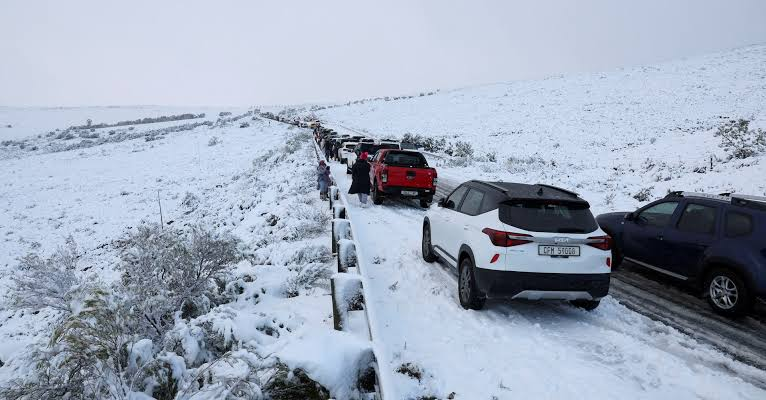
The weather is set to become more severe by Wednesday, as another cold front moves through. This system will bring additional rain and snowfall to mountainous areas. Snow accumulation is particularly likely in parts of the Eastern Cape, including Mthatha, Aliwal North, and Barkly East. Some snowfall is also possible in elevated regions of the Free State and KwaZulu-Natal.
With freezing conditions predicted midweek, there is a high risk of road closures, power outages, and travel delays—especially in rural and mountainous areas. Residents are advised to monitor updates closely and avoid unnecessary travel during periods of peak weather activity.