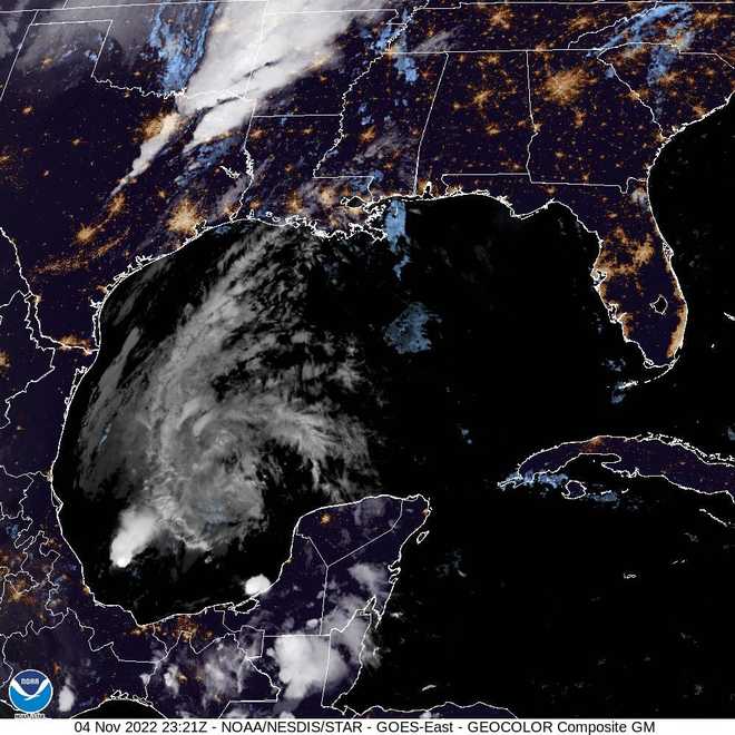
Tropical Depression Lisa slows within the Bay of Campeche
SITTING ACROSS THE MIDSECTION COUNTRY. LET’S GET TO THE TROPICS BECAUSE GOT A LOT OF STUFF TO TALK ABOUT AS FAR AS WE HEAD INTO THE WEEKEND AND INTO NEXT WEEK AS WELL. SO OBVIOUSLY THIS POPS OUT TO YOU AND YOU’RE THINKING WHAT’S GOING ON IN HERE. AND THIS IS AN ODD SHADED AREA, A MODERATE CHANCE THAT WE COULD SEE SOMETHING DEVELOP OVER THE NEXT FIVE DAYS. SO WHAT WE’RE SEEING RIGHT NOW IS THIS JUST LINEAR LINE OF LOW PRESSURE THAT’S SITTING THERE. IT’S NOT ORGANIZED YET, BUT THE HURRICANE CENTER THINKS THAT AS WE HEAD FORWARD INTO TIME LATER THIS AND INTO NEXT WEEK THAT WE COULD SEE A BROAD, WEAK AREA OF LOW PRESSURE DEVELOP WEDNESDAY INTO THURSDAY. SO THIS WILL START IMPACT OUR WEATHER INTO NEXT WEEK AS WELL AS IT’S GOING TO GIVE US LOTS MORE TROPICAL MOISTURE. IT IS GOING TO INCREASE OUR WINDS JUST A LITTLE BIT. AND THEN BY THURSDAY, YOU CAN SEE WE DO HAVE THIS AREA DISTURBED WEATHER RIGHT ON TOP OF US. SO WHAT WILL BE LOOKING FOR IS RAIN, WIND, FUNNEL, BEACH EROSION, JUST A MESSY SETUP BY MIDWEEK. SO HERE’S WE’LL BE TRACKING AS WE’LL BE WATCHING THIS LOW THIS WEEKEND INTO NEXT WEEK SHOWERS, STORMS. WINDS WILL BE PICKING AND THERE WILL BE A THREAT FOR FUNNEL CLOUDS. IT’S JUST GOING TO BE MESSY TUESDAY, WEDNESDAY AND TO THURSDAY. DO YOU NEED TO WORRY ABOUT THE WINDS? THE ANSWER RIGHT NOW IS NO, WE CAN HANDLE WIND GUSTS OF 35 TO 40 MILES PER HOUR. NOT TOO CONCERNED WITH, BUT THERE WILL BE A LOT OF RAIN AND FUNNEL CLOUDS OUT THERE WILL BE THE ONE OF THE THREATS WE’LL BE WATCHING ON TOP OF THAT JUST ROUGH SURF BEACH EROSION IS GOING TO BE A MESSY SYSTEM MOVING IN, BUT WILL BE MOVING OUT BY FRIDAY. THEN WE GET THE PAY OFF AND NICE, STRONG COOL FRONT TO WORK ITS WAY IN NEXT WEEKEND. SO FORECAST FOR NICE LITTLE STEADY EASTERLY BREEZE CONTINUE AS IT KEEPS A SCATTERED SHOWER IN THE FORECAST. SAME DEAL ON SUNDAY. A LITTLE LESS ON THE RAIN BUT NOTICE THE WIND ARROWS AS WE GO INTO MONDAY. THAT ONE’S GOING TO BE HOWLING RIGHT OFF THE OCEAN AND THAT’S GOING TO HELP KEEP OUR TEMPERATURES NICE AND MILD COMFORTABLE. BUT THEN EVENTUALLY WE’LL GET INTO THAT TROPICAL MOISTURE STARTING REALLY ON TUESDAY. SO WAVE HEIGHTS VOTING, UNFORTUNATELY, THIS WEEKEND DOESN’T THAT GOOD THE ALREADY UP TO SIX FEET CLOSE TO THE GULF STREAM AND EASILY BREEZE IS GOING TO BE GUSTY AT TIMES TOMORROW SO 4 TO 7 FEET SO, SMALL CRAFT ADVISORY PROBABLY GOING TO BE ISSUED FOR TOMORROW. SO MID EIGHTIES AND WINDY AS WE THROUGH SATURDAY INTO SUNDAY MONDAY. TUESDAY TROPICAL MOISTURE MOVES IN WINDY RAINY AT TIMES WEDNESDAY INTO THURSDAY. AND THEN BY FR
Tropical Depression Lisa slows within the Bay of Campeche
Video above: The latest forecast from First Warning Weather meteorologistsLisa is shifting over the Bay of Campeche as a tropical melancholy. It is anticipated to develop into a remnant low Friday night time or Saturday.As of 5 p.m. Friday, Lisa is 235 miles west of Ciudad del Carmen, Mexico. It has most sustained winds of 30 mph and is shifting northwest at 5 mph. Weather | Radar | Hurricanes | Traffic | uLocal | Facebook | Twitter | Instagram First Warning Weather OutlookLisa is anticipated to dissipate by Monday, WPBF First Warning Weather meteorologists mentioned. There isn’t any menace to Florida.”Lisa or its remnants are then forecast to stall or drift southward through the remainder of the weekend,” the National Weather Service mentioned in its latest forecast replace. Informational: 2022 WPBF 25 First Warning Weather Hurricane Survival GuideWatches and warningsThere are not any watches or warnings in impact presently.WATCH: WPBF 25 Storm Shorts: Slow-moving storms This comes as a disturbance is anticipated to convey moisture to Florida because it continues to rebuild after Hurricane Ian.Stay up to date on the latest climate updates with the WPBF 25 News app. You can obtain it right here.
Video above: The latest forecast from First Warning Weather meteorologists
Lisa is shifting over the Bay of Campeche as a tropical melancholy. It is anticipated to develop into a remnant low Friday night time or Saturday.
As of 5 p.m. Friday, Lisa is 235 miles west of Ciudad del Carmen, Mexico. It has most sustained winds of 30 mph and is shifting northwest at 5 mph.
Weather | Radar | Hurricanes | Traffic | uLocal | Facebook | Twitter | Instagram
First Warning Weather Outlook
Lisa is anticipated to dissipate by Monday, WPBF First Warning Weather meteorologists mentioned. There isn’t any menace to Florida.
“Lisa or its remnants are then forecast to stall or drift southward through the remainder of the weekend,” the National Weather Service mentioned in its latest forecast replace.
Informational: 2022 WPBF 25 First Warning Weather Hurricane Survival Guide
Watches and warnings
There are not any watches or warnings in impact presently.
WATCH: WPBF 25 Storm Shorts: Slow-moving storms
This comes as a disturbance is expected to bring moisture to Florida because it continues to rebuild after Hurricane Ian.
Stay up to date on the latest climate updates with the WPBF 25 News app. You can obtain it here.


